Decision support system for surface water quality assessment (SWQAT)
TRL level:
Technology Demonstration (TRL-4)
Executive Summary/Description of the software
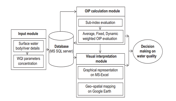
The Overall Index of Pollution (OIP) simplifies water quality assessment by combining 14 physicochemical, toxicological, and bacteriological parameters into a single value ranging from 0 to 16. This index classifies water quality as 'Excellent' to 'Heavily Polluted.' High OIP values indicate poor water quality. The user-friendly, standalone Surface Water Quality Assessment Tool (SWQAT) computes OIP values and displays them on Google Maps, providing a convenient method for water quality assessment and visualization.
Salient Technical features
Real-time generation of OIP occurs by entering component parameter values into the respective database for multiple rivers and sampling stations.
Assessment of overall water quality status is based on 14 different water quality parameters.
Mapping of sampling stations, water quality classification, and OIP values is done on Google Maps.
Problem being addressed/Application
Water quality assessment often varies due to subjective WQIs, index weights, and classification schemes. Hence, to address this, a user-friendly tool called the Surface Water Quality Assessment Tool (SWQAT) was developed for routine and strategic water quality monitoring in India. SWQAT calculates OIP values with dynamic parameter weights and offers water quality classification tailored to the Indian context, aiding regular water quality assessments with more accuracy and ease of understanding.