CSIR

CSIR-National Environmental Engineering Research Institute Nagpur, India

NEERI
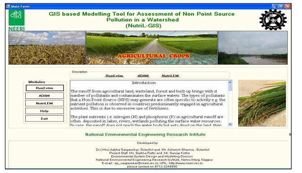
NutriL-GIS: A Tool for Assessment of Agricultural Runoff and Nutrient Pollution in a Watershed
TRL level:
Technology Demonstration (TRL-4)
Depiction
...
Figure depicts the homepage of NutriL-GIS.
Executive Summary/Description of the software
NutriL-GIS is a user-friendly, platform-independent, stand-alone application incorporating GIS features and functionalities for analysis and computing rainfall-runoff and nutrient load from non-point source pollution
Salient Technical features
NutriL-GIS integrates applications developed in the .Net framework. It has three computational modules: RunEstim: Simulates rainfall-runoff in a watershed. ADAM: Analyzes agricultural data and estimates nutrient levels remaining in soil. NutriLem: Assesses distributed nutrient load in a watershed. The tool facilitates the delineation of micro-watersheds, where best management practices (BMPs) like constructing buffer strips, settling ponds, and riparian zones can be implemented to mitigate agricultural runoff into the mainstream.
Problem being addressed/Application
Assessing nutrient pollution from agricultural land within watersheds is complex due to its diffuse nature. Existing models require extensive data and expertise in hydrology and GIS for preprocessing and post-processing. This limits their practicality in watershed management decision-making.
Level/Scale of Development
The software is implemented at Kanhan River sub-watershed in Nagpur District, India.
IP Status
Copyright Granted on Oct 16, 2009.Copyright Registration No: O34CR2009
Status of commercialization including status of deployment
Under Process
Techno-economics
Viable
Environmental Considerations
Yes
Project Duration
Jan. 1, 2008
-
Dec. 31, 2010
Funding Agency
CSIR, New Delhi
Developed by
Er Asheesh Sharma, Principal Scientist, CSIR-NEERI & Dr Aabha Sargaonkar, Chief Scientist (retired), CSIR-NEERI
Project Leader
Er Asheesh Sharma
Objectives
The software aims to facilitate micro-watershed delineation, enabling the implementation of best management practices (BMPs) to mitigate agricultural runoff into the main stream.
Disclaimer
The software is developed solely to showcase the proof of concept through a case study in Kanhan River sub-watershed in Nagpur District, India. For large-scale implementation, necessary customization needs to be coordinated with the developer.
Video
None
Copyright
Website
:
Employee Details
For any query regarding this website, please contact: CTMD, CSIR-NEERI, Nagpur
Content on this website is published and managed by CSIR-National Environmental Engineering Research Institute