CSIR-National Environmental Engineering Research Institute Nagpur, India
Grid Classification
TRL level:
-
Depiction
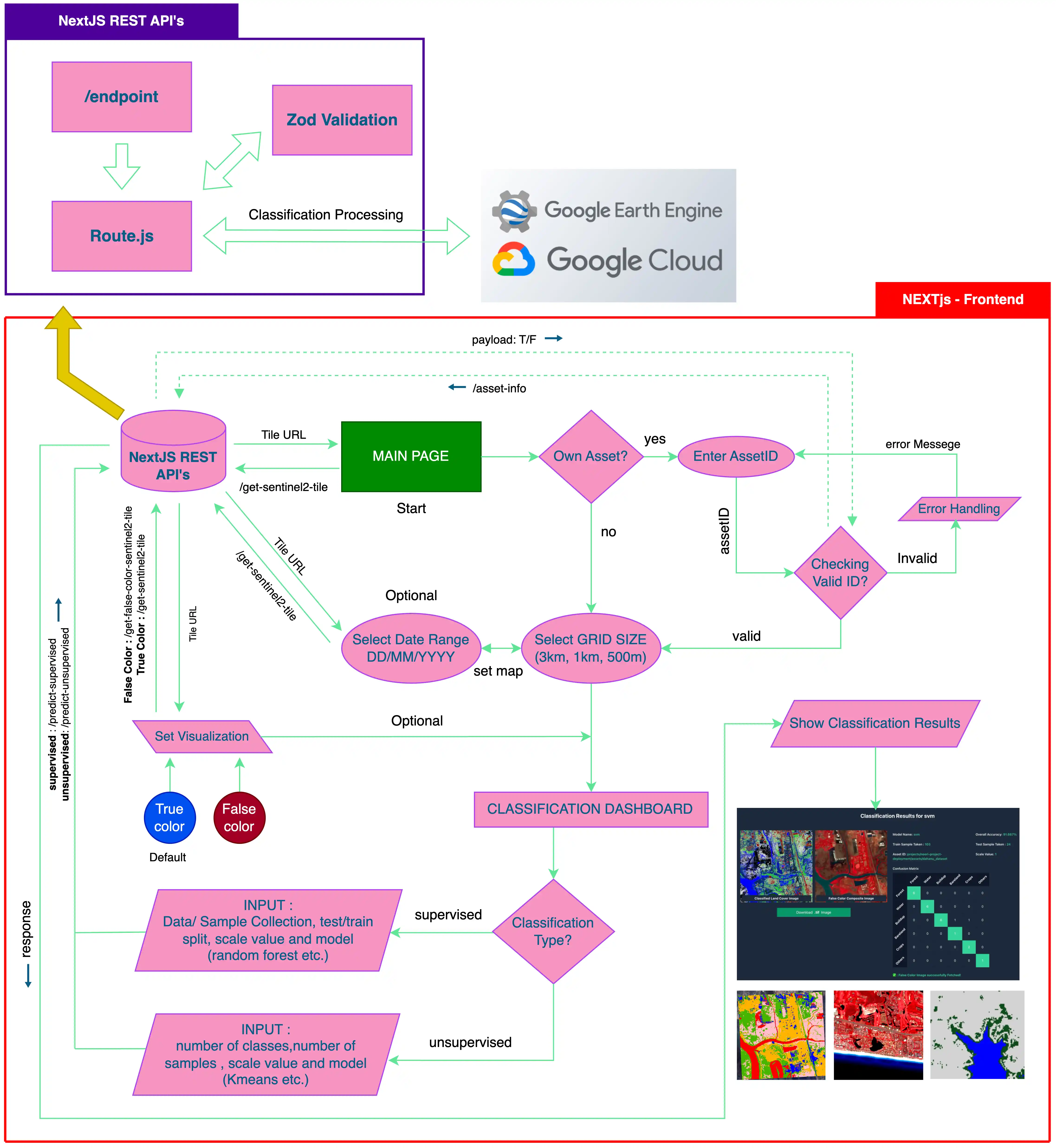
Figure depicts the concept: Grid Classification
Executive Summary/Description of the software
The primary aim of this project is to develop a generalized, scalable, and easy-to-use system for Land Use and Land Cover (LULC) classification using both supervised and unsupervised machine learning algorithms. The project is designed to address the increasing demand for automated geospatial analysis tools that can efficiently process and classify high-resolution satellite images. By targeting a range of grid sizes — including 3km x 3km, 1km x 1km, and 500m x 500m — the system provides the flexibility needed for various environmental and planning applications.
Salient Technical features
Access and classify satellite image grids at multiple resolutions (3km, 1km, 500m) from any device.The classification system is secured and containerized via Docker with controlled cloud deployment.Supports both supervised and unsupervised machine learning models for flexible classification.Real-time visualization of classified outputs via a web-based interactive map interface.Seamless integration with Google Earth Engine for efficient remote sensing and preprocessing.Outputs are compatible with common GIS and environmental planning software tools.
Problem being addressed/Application
ML models (RF, SVM, XGBoost) classify labeled data with high accuracy. Unsupervised learning (KMeans, KMeans++) handles unlabeled data. This dual approach adapts to diverse datasets for environmental monitoring, urban planning, and agriculture.
Level/Scale of Development
The system is capable of performing land use and land cover classification on any selected geographic region, with a maximum grid size of 3 km by 3 km.
IP Status
-
Status of commercialization including status of deployment
-
Techno-economics
Viable
Environmental Considerations
NA
Project Duration
Feb. 2, 2025
-
May 30, 2025
Funding Agency
CSIR-NEERI, Nagpur
Developed by
Hemanshu Waghmare
Project Leader
Dr Asheesh Sharma
Objectives
- To design and implement a modular and scalable backend using FastAPI, capable of processing image classification requests efficiently. - To integrate a range of machine learning algorithms, including supervised models (Random Forest, SVM, XGBoost) and unsupervised models (KMeans, KMeans++), to handle diverse classification scenarios.- To preprocess high-resolution satellite imagery by performing grid-based classification at multiple spatial resolutions, including 3km x 3km, 1km x 1km, and 500m x 500m, converting the data into structured formats suitable for training, evaluation, and prediction.- To build an intuitive and interactive frontend using Next.js and TailwindCSS, with Leaflet integration for dynamic map-based visualization of classification outputs.
Disclaimer
This system has been developed as a proof of concept for automated Land Use and Land Cover (LULC) classification using a case study focused on user given area India. For broader-scale or region-specific deployment, further customization and configuration should be undertaken in collaboration with the system developer.
For any query regarding this website, please contact: CTMD, CSIR-NEERI, Nagpur
Content on this website is published and managed by CSIR-National Environmental Engineering Research Institute